It’s been called the “Moby Dick of conspiracy theories”[1]. It’s been attached to some of the most advanced research groups in the United States military, including the Naval Research Laboratory and the clandestine Defense Advanced Research Projects Agency (DARPA). And, depending on who you ask, this secluded, $250 million facility north of Gakona, Alaska may be implicated in some of the most devastating natural disasters of our time, including the 2011 Tōhoku Earthquake and Tsunami, the 2010 Haiti Earthquake, and the April 2011 Tornado ‘Superoutbreak’. So, what exactly is this alleged superweapon?
According to its website at the University of Alaska, The High Frequency Active Auroral Research Program, or HAARP, was established in 1993 as “a program focused on the study of upper atmospheric and solar-terrestrial physics and Radio Science.”[2] The HAARP facility consists of a number of research instruments including receivers, magnetometers, riometers, radars, and other tools. The primary instrument in use by HAARP, however, is a 180-antenna gridded array spanning 33 acres, known as the ‘Ionosphere Research Instrument’ (IRI), which is used to “stimulate small, well-defined volumes of ionosphere.” The stated goal of these instruments is to study the behavior and composition of a layer of the Earth’s atmosphere called the Ionosphere. The Ionosphere is a region of the atmosphere, about 50 miles above the surface, in which the Sun’s solar radiation strikes atoms of various atmospheric gases and causes them to produce both a free electron and a positively charged ion. Where this happens, the atmosphere begins to behave less like a gas and more like a plasma. The altered behavior of these regions allows us to use long distance, high frequency communications systems, among other things, by bouncing signals off the Ionosphere through a process called sky-wave propagation.
The purported goal of HAARP is to study this region of the atmosphere in order to better understand and improve on various technologies that use the Ionosphere, from transoceanic aircraft and ship-to-shore communications, to military communication systems, to GPS navigation and surveillance applications. This research is done by transmitting a narrow band of intense radio signals into specific, localized areas of the Ionosphere. So.. what’s the big deal? Well, let’s run through some of the more sinister applications HAARP has allegedly been involved in. But, before we begin, let me make a disclaimer. I’m not an expert. Not in anything. And I don’t have a degree or any other qualifications that I can use to present myself as such. I don’t have any authority, and I have no interest in pretending otherwise. What I do have is an intense curiosity in nearly everything, a penchant for critical thinking and rational analysis, a passion for meteorology, and a desire to give every idea the most equal and thorough evaluation that my understanding and ability permits. So, without further ado, on to the claims.
There’s a Storm A-Brewin’
The first claim we’ll be evaluating is that of weather modification. On the surface, this certainly seems to be a reasonable possibility. After all, HAARP is transmitting radio signals into the atmosphere, with one of the goals being a rapid heating of a volume of gas. Since weather is largely fueled by temperature differences in the atmosphere, it sounds plausible that this would affect our surface weather. In fact, several people claim to have found proof of this weather modification technology in the form of strange shapes and designs on weather radar. These shapes come in two flavors, so-called ‘HAARP rings’ and ‘scalar squares’. Let’s take a look at one of the more outspoken proponents of these phenomena, a Youtube user named “Dutchsinse”. Below is a video from April 27, 2011, the most active day of the late April Superoutbreak.
In this video you can see both ‘HAARP rings’ and ‘scalar squares’, and the role they are claimed to play in forecasting severe weather. By clicking here you can see a summary of confirmed tornadoes on April 27. And, sure enough, many of the general areas pointed to in the video (though few of the specific towns) did experience tornadoes. It certainly sounds impressive. Impressive enough, in fact, that it’s easy to see why some people would view this as proof of HAARP’s ability to modify weather. But, we’re not going to take things at face value. Instead, we’re going to examine whether there could be any other explanation for the various occurrences in this video and others like it.
Let’s start with the most basic question – is there any other reason this person would have cause to suspect severe weather in the aforementioned areas? Well.. yes, actually. I’d been expecting a large and dangerous tornado outbreak across the southeast for several days prior to the event, and I was certainly not alone. Any meteorologists or weather enthusiast, professional or otherwise, who had been paying attention to the developing situation across the south could have (and did) forecast the same thing. The Storm Prediction Center (SPC) had issued a large area of high and moderate risk, including a very rare 45% tornado probability for a large area on April 27. Every ingredient necessary for an historic outbreak was present.[3] Many people knew that the situation in the south was going to be bad, it was simply a question of just how bad.
Let’s also not lose sight of the fact that this was a massive, extended outbreak. An historically massive outbreak, in fact. It’s not as if these tornadoes suddenly developed out of a clear blue sky, by the time the April 27 video was made this intense weather system had already left a legacy of destruction across the south and midwest. With a total of 336 confirmed tornadoes, you could have simply named any town in Alabama, Mississippi, Tennessee, or several other states and chances are fair that a tornado occurred somewhere in that general area. Between the massive CAPE levels (a measure of the amount of energy available for severe weather), very high low-level and deep-layer wind shear (variation in wind direction and speed with height, which causes rotation in the atmosphere), a deep moisture feed, and other factors, a devastating tornado outbreak was all but assured. In fact, if it weren’t for the very early warnings, it’s possible the death toll could have been even higher than it was.[4] For anyone interested, here are a couple more excellent links explaining the extraordinary synoptic setup that led to the April Superoutbreak.
Wikipedia Meteorological Summary
Okay, so the tornado outbreak was pretty common knowledge for anyone with even a passing interest in meteorology. But what about the strange patterns themselves? Certainly such bizarre occurrences can’t be explained by traditional means, so they must represent the fingerprints of HAARP’s weather modification. Well.. once again, we need to slow down a little bit. These are certainly odd patterns and shapes, and they deserve a closer look. Let’s see a couple of other examples of these and other similar things on radar in an attempt to figure out exactly what we’re dealing with here.


For convenience, I recommend opening these images in a different tab or window either by clicking with your scroll wheel, or right clicking and ‘open in new tab/window’.
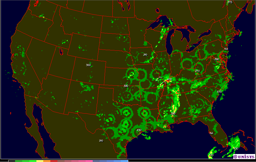
The image on the left is a radar composite of the continental United States, showing what appears to be a large number of these HAARP rings. The center image is a single radar from Minneapolis, showing several distinctly circular patterns as well as a couple of straight lines. The right image shows a very clearly defined straight line on a radar from Hong Kong. Since the last image is already labeled, let’s start there. The straight line is the result of sunlight interacting with the radar waves and producing a false echo. That’s right, sunlight can sometimes cause issues with radar, which gives some indication as to how error-prone they can sometimes be. But, before we go further, let’s quickly explore exactly what radar is and how it works.
Radar works by sending out a pulse of radar waves in a circular sweep pattern (keep this in mind, it’ll be important in a minute) and recording the ‘echo’ that it receives back, as well as the strength of the return. These ‘echoes’ are intended to reflect where precipitation is located in the atmosphere, thus allowing us to visually track and analyze weather systems. At least, that’s the way it’s intended to work. In reality, it’s not quite so simple. Our radar technology has advanced immensely in recent years, but a number of problems still remain. Any number of non-weather related things can cause false returns, most notably ground clutter, flocks of birds, insect swarms, chaff (material designed to distort radar returns) dropped from military planes, bats, dense fog, and yes, sunlight. Anomalous propagation and false echoes like these are responsible for nearly all misidentified anomalies and phenomena on radar. Most radars now have computer algorithms that detect and remove much of this detritus, but not all. And since radars depend on computers for such things now, they’re also prone to data errors, rendering errors, and other computer glitches. Plus, if things weren’t already confusing enough, you must also consider that each radar scan is done at a specific angle, giving a thin ‘slice’ of the atmosphere at a certain elevation. Most radar images show only one ‘slice’ at a time, but some (called ‘composite radar’) show all the slices blended together. Add all this together and it becomes clear that radar is certainly not as simple as ‘what you see is what you get’.[5]
So, back to the pictures above. Recall that the first picture showed what appeared to be a great number of HAARP rings. It’s certainly spooky looking to the average person, but anyone with the ability to decipher radar scans can immediately tell you these signals are caused by dense fog. Because fog is essentially a cloud on or near the ground, if dense enough it can cause a return similar to a weak cloud. This also explains the widespread nature of these patterns, since it happened very early in the morning when fog is most prevalent and widespread. If you find the center of each ring, you can also see these aren’t at all random. Actually, at the center of each ring is a radar station.[6] The reason for the circular pattern is even more evident in the second image, which clearly displays the circular sweep pattern that radar stations use to scan the surrounding atmosphere. In the northeast quadrant, the boundary between red-orange and purple illustrates the normal scanning range of the radar station, beyond which echo returns tend to become distorted and more circular or arc-shaped.
In the April 27 video, however, these rings are not caused by fog. There are other issues, however. First, the radar being used is the ‘Intellicast’ radar, which you can find right here. Remember I mentioned that not all radar programs are equal? This is a fine example. While the Intellicast radar may be fine for giving a general approximation of where weather systems are, what type of precipitation is falling, and other general uses, it is also rife with problems. First, the resolution (meaning, the amount of detail it can pick up) is lower than the high precision radars generally used in weather forecasting. Second, the algorithms used to ‘declutter’ all of the false echoes we looked at earlier are poor compared to high quality radar programs. And third, this type of radar display is notorious for rendering errors which routinely cause all manner of odd shapes, patterns and assorted anomalies. Combine these factors together, and you’ve got the reason why Intellicast is so often used in conjunction with this theory – it’s more prone to these sorts of errors than higher quality radars and will therefore show these rings and other anomalies more often. And finally, the radar shown in the video is a composite radar, meaning that it is a collection of scans from all the individual radar stations combined into one radar. This is the reason that rings can so often be seen, oftentimes intersecting and overlapping each other. Each ring is simply an artifact which appears at the outermost extent of the scanning range for a given radar. When several of these radars are in close proximity, you can sometimes see several of these ‘range rings’ intersecting.
In the interest of time, I’ll provide a few links that explain the multiple causes of this ‘HAARP ring’ phenomenon in much more depth. I’d encourage everyone to check out at least a couple of them for a better understanding of how it works.
Anomalous Propagation and False Echoes
Concentric Radar Rings – A Case Study
An Evaluation of ‘Anomalous’ Radar Images
So, as you can hopefully see after digging around a bit, these phenomena are simply the result of misidentification of radar quirks that are well-known throughout the meteorological community. That these entirely innocuous patterns are being touted by some as harbingers of death and destruction wrought by a mysterious government superweapon ought to reveal something about the trustworthiness of such individuals. But, in the interest of being thorough I will follow this post with a second part outlining and discussing several other claims made about HAARP. In the meantime, I’d like to encourage you to please evaluate these claims for yourself. Keep an open mind, but also dig deeply, think critically, and look past tactics of persuasion and false authority in order to arrive at the truth. The desire to believe that there’s something more to reality other than what we see and what we’re told resides within all of us. It should never be extinguished, but it also should never be followed blindly. Follow your instincts, explore every dark corner, but let discernment and critical thinking be your light.
